Satellite Communication
Possible Exam Questions
Exam Questions and Answer Map
Questions marked [PYQ paper/year] reproduce an observed past-paper question; [likely] denotes a pattern-based prediction. Multi-part PYQs retain their original mark split.
-
What do you mean by satellite communication? State Kepler's laws of orbital motion. Which kind of loss is the most important while transmitting signals through the earth's atmosphere (above 10 GHz)? Justify your answer. [2+3+5=10] — [PYQ 2079]
-
Answer plan: Define the satellite relay and label uplink/transponder/downlink [2] → state all three Kepler laws and the period relation [3] → identify rain attenuation, justify absorption/scattering and frequency dependence, qualify gaseous absorption, and list mitigation [5].
-
Model answer: Satellite Communication, Kepler's Laws, and Atmospheric Loss
-
Classify satellite orbits; compare LEO, MEO and GEO. [10] — [likely]
-
Answer plan: Define orbit by altitude → draw concentric orbits diagram → tabulate LEO/MEO/GEO/HEO by altitude, period, delay, path loss, coverage, satellites needed, and uses → state GEO conditions (equatorial, circular, 35786 km, same direction).
-
Model answer: Satellite-Orbit Classification and LEO–MEO–GEO Comparison
-
What factors affect uplink and downlink design in a geostationary satellite system? [5] — [PYQ 2081]
-
Answer plan: List factors: EIRP, free-space path loss, atmospheric/rain attenuation, antenna gain/G-T, transponder power and bandwidth, frequency band, pointing loss → write link budget equation \(C = EIRP + G_r - L_{fs} - L_{other}\) → explain why uplink frequency is higher.
-
Model answer: GEO Uplink and Downlink Design Factors
-
Explain satellite stabilization, tracking and the role of earth stations. [10] — [PYQ-linked 2081 composite]
-
Answer plan: Define station-keeping and stabilization (spin/3-axis) → explain tracking (antenna pointing using program/auto track) → describe earth station subsystems (antenna, HPA, LNA, up/downconverter, modem, tracking, M&C) → write antenna gain formula \(G = \eta(\pi D/\lambda)^2\) → define G/T.
- Model answer: Satellite Stabilization, Tracking and Earth Stations
Scope of this Chapter
This chapter covers the Satellite Communication part of NTC Paper II, Section B, Topic 7: orbits, Kepler's laws, link budget, earth stations, VSAT, and signal-to-noise ratio.
1. Introduction to Satellite Communication
Likely Exam Question (5 marks)
"What is satellite communication? Draw a basic satellite communication link."
Definition
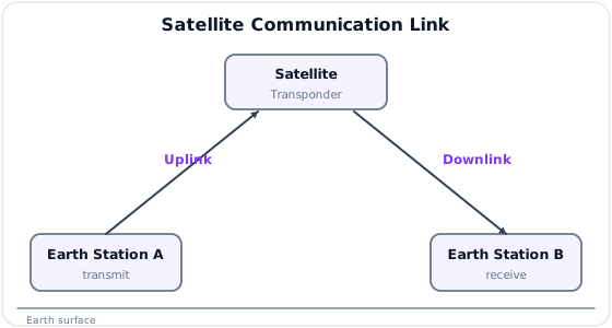
Satellite communication uses an artificial satellite as a repeater or relay station to receive, amplify, frequency-convert, and retransmit signals between earth stations.
Basic Link
| Link | Meaning |
|---|---|
| Uplink | Signal transmitted from earth station to satellite |
| Downlink | Signal transmitted from satellite to earth station |
| Transponder | Satellite subsystem that receives, amplifies, converts frequency, and retransmits |
Uses
- Television and radio broadcasting.
- Long-distance telephony and data links.
- Internet backbone and rural connectivity.
- VSAT networks for banks, offices, and remote sites.
- Mobile satellite services.
- Navigation, weather, remote sensing, and disaster communication.
Advantages
| Advantage | Explanation |
|---|---|
| Wide coverage | One satellite can cover very large geographical area |
| Broadcast capability | Same signal can serve many receivers |
| Useful in remote areas | No need for terrestrial cable infrastructure |
| Rapid deployment | Suitable for emergency and temporary networks |
| Distance-insensitive cost | Cost does not increase strongly with distance within coverage |
Limitations
| Limitation | Explanation |
|---|---|
| High propagation delay | Especially in GEO links |
| High launch and satellite cost | Space segment is expensive |
| Free-space path loss | Very large distance causes high loss |
| Rain attenuation | Important at Ku, Ka, and higher bands |
| Limited satellite power | Transponder power and bandwidth are limited |
2. Satellite Orbits
Likely Exam Question (10 marks)
"Classify satellite orbits. Compare LEO, MEO, and GEO satellites."
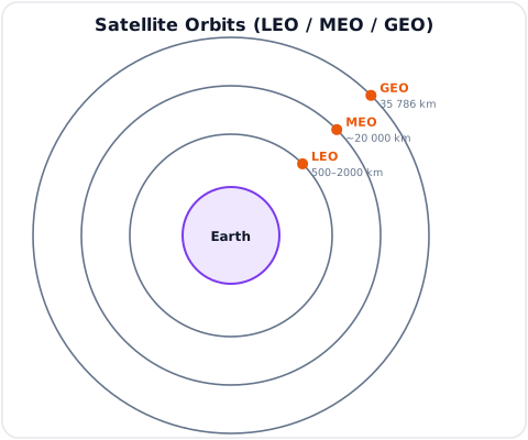
Orbit Classification by Altitude
| Orbit | Altitude | Period | Main Uses |
|---|---|---|---|
| LEO | About \(500\) to \(2000\,\text{km}\) | About 90 to 120 min | Mobile satellite, imaging, LEO internet constellations |
| MEO | About \(2000\) to \(20000\,\text{km}\) | Several hours | Navigation systems such as GPS |
| GEO | About \(35786\,\text{km}\) above equator | 24 hours | TV broadcast, fixed satellite services, VSAT |
| HEO | Highly elliptical | Varies | High-latitude coverage |
LEO
Advantages:
- Low propagation delay.
- Lower path loss than GEO.
- Suitable for broadband constellations and mobile services.
Limitations:
- Satellite moves quickly relative to earth.
- Many satellites are needed for continuous coverage.
- Frequent handover between satellites.
MEO
Advantages:
- Fewer satellites than LEO for global coverage.
- Moderate delay and path loss.
- Suitable for navigation systems.
Limitations:
- More delay than LEO.
- Still requires tracking or constellation planning.
GEO
Geostationary Earth Orbit (GEO) is a circular equatorial orbit in which the satellite appears stationary relative to earth.
Conditions for geostationary orbit:
- Circular orbit.
- Equatorial plane.
- Same direction as earth rotation.
- Orbital period equal to one sidereal day.
Advantages:
- Fixed earth station antennas can point at one position.
- Large coverage area.
- Three GEO satellites can approximately cover most of the earth except polar regions.
- Good for broadcasting and fixed services.
Limitations:
- High propagation delay.
- Large path loss.
- Poor polar coverage.
- Launch and station-keeping cost is high.
LEO vs MEO vs GEO
| Feature | LEO | MEO | GEO |
|---|---|---|---|
| Altitude | Low | Medium | \(35786\,\text{km}\) |
| Delay | Lowest | Medium | Highest |
| Path loss | Lowest | Medium | Highest |
| Earth coverage per satellite | Small | Medium | Large |
| Satellites needed for global coverage | Many | Moderate | Few |
| Antenna tracking | Usually needed | Usually needed | Not needed for fixed terminals |
| Common use | LEO broadband, imaging | GPS/GNSS | TV, VSAT, FSS |
3. Orbital Terms
Likely Exam Question (5 marks)
"Define apogee, perigee, inclination, and footprint in satellite communication."
| Term | Meaning |
|---|---|
| Apogee | Farthest point of satellite orbit from earth |
| Perigee | Nearest point of satellite orbit from earth |
| Inclination | Angle between orbital plane and equatorial plane |
| Sub-satellite point | Point on earth directly below the satellite |
| Footprint | Area on earth covered by satellite antenna beam |
| Elevation angle | Angle between earth station antenna direction and local horizon |
| Azimuth angle | Horizontal pointing angle of antenna measured from north |
| Look angle | Required azimuth and elevation angles to point antenna at satellite |
| Station keeping | Maintaining satellite position against orbital perturbations |
Footprint
The footprint depends on satellite altitude, antenna beamwidth, and earth geometry.
GEO satellites have large footprints, while LEO satellites cover smaller moving footprints.
4. Kepler's Laws
Likely Exam Question (10 marks)
"State Kepler's laws of planetary motion and explain their importance in satellite communication."
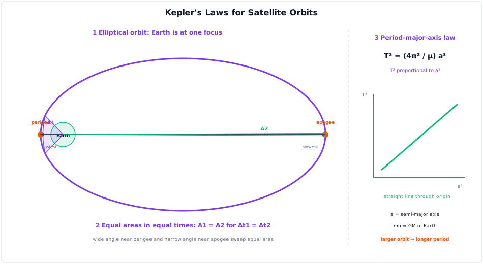
Kepler's laws describe the motion of satellites around a central body such as earth.
First Law - Law of Orbits
Satellites move in elliptical orbits with the earth at one focus.
For a circular orbit, the ellipse becomes a circle and earth is at the center.
Second Law - Law of Areas
The line joining the satellite and earth sweeps out equal areas in equal times.
This means a satellite moves faster near perigee and slower near apogee.
Third Law - Law of Periods
The square of orbital period is proportional to the cube of the semi-major axis.
where:
- \(T\) = orbital period
- \(a\) = semi-major axis
- \(\mu = GM\) = earth's gravitational parameter
For a circular orbit of radius \(r\):
Orbital velocity for circular orbit:
Importance
- Determines satellite orbital period.
- Helps calculate GEO altitude.
- Used in tracking and prediction of satellite position.
- Explains speed variation in elliptical orbit.
5. Frequency Bands Used in Satellite Communication
Likely Exam Question (5 marks)
"Write short notes on C-band, Ku-band, and Ka-band satellite communication."
| Band | Approx. Uplink | Approx. Downlink | Features |
|---|---|---|---|
| L-band | 1 to 2 GHz | 1 to 2 GHz | Mobile satellite, GPS; low rain fading |
| S-band | 2 to 4 GHz | 2 to 4 GHz | Mobile, telemetry, weather radar |
| C-band | 6 GHz | 4 GHz | Reliable in rain, larger antennas |
| X-band | 8 GHz | 7 GHz | Military and government |
| Ku-band | 14 GHz | 11/12 GHz | VSAT, DTH TV; smaller antennas |
| Ka-band | 30 GHz | 20 GHz | High-throughput satellites; more rain fade |
Why Uplink Frequency Is Usually Higher
In many satellite systems, uplink frequency is higher than downlink frequency because earth stations can transmit higher power and use larger antennas, while the satellite has limited transmit power.
6. Satellite Transponder
Likely Exam Question (5 marks)
"What is a satellite transponder? Explain its main functions."
Definition
A transponder is a satellite subsystem that receives uplink signals, amplifies them, changes their frequency, and retransmits them toward earth.
Basic Transponder Block

Functions
- Receive weak uplink signal.
- Amplify with low noise amplifier (LNA).
- Convert uplink frequency to downlink frequency.
- Filter assigned channel bandwidth.
- Amplify downlink signal using high power amplifier (HPA).
- Retransmit signal to the required coverage area.
Bent-Pipe and Regenerative Transponder
| Type | Description |
|---|---|
| Bent-pipe transponder | Amplifies and frequency-converts without demodulating signal |
| Regenerative transponder | Demodulates, processes, remodulates, and retransmits signal |
7. Earth Station
Likely Exam Question (10 marks)
"Explain the main subsystems of a satellite earth station."
Definition
An earth station is a ground-based station used to transmit and receive signals to and from a communication satellite.
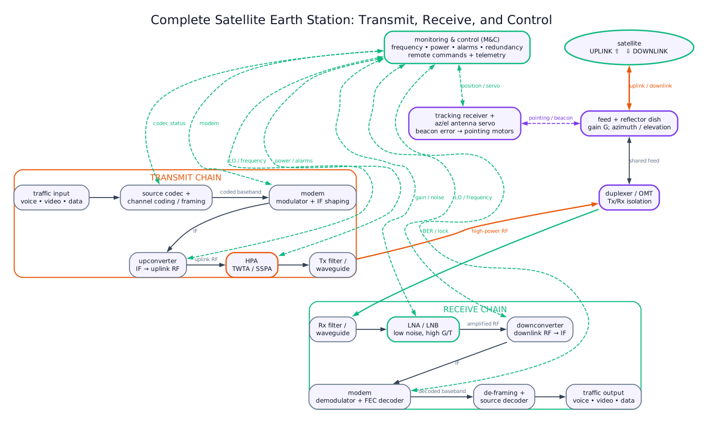
Earth Station Subsystems
| Subsystem | Function |
|---|---|
| Antenna system | Focuses transmitted and received microwave energy |
| HPA | High power amplifier for uplink transmission |
| LNA/LNB | Low noise amplifier/block for weak downlink reception |
| Upconverter | Converts IF to uplink RF frequency |
| Downconverter | Converts received RF to IF/baseband |
| Modem | Performs modulation, demodulation, coding, and framing |
| Tracking system | Keeps antenna pointed to satellite if required |
| Power supply | Provides stable operating power |
| Monitor and control | Supervises equipment alarms and performance |
Antenna Gain
Parabolic dish antenna gain:
In dBi:
where:
- \(\eta\) = antenna efficiency
- \(D\) = dish diameter
- \(\lambda\) = wavelength
G/T Ratio
Earth station receiving performance is often measured by G/T:
In dB form:
where \(T_s\) is system noise temperature in kelvin.
Higher G/T means better receiving capability.
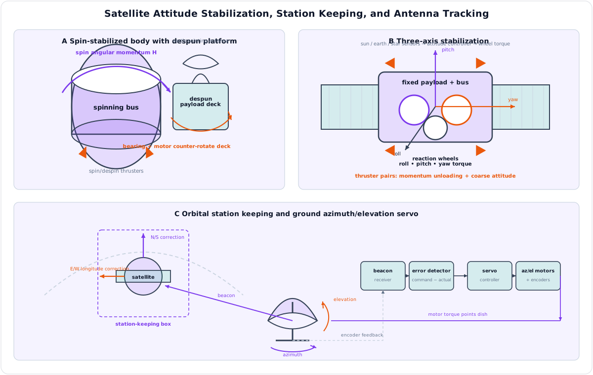
Satellite Stabilization, Station Keeping, and Tracking
- Spin stabilization uses body angular momentum for passive attitude stiffness; a bearing and motor keep the communications payload and antenna on a despun, Earth-pointing platform.
- Three-axis stabilization uses attitude sensors, a controller, and orthogonal reaction wheels for roll, pitch, and yaw; thrusters provide coarse correction and unload accumulated wheel momentum.
- Station keeping applies north-south and east-west thruster corrections to hold the assigned orbital position.
- Ground tracking converts beacon pointing error into azimuth and elevation motor commands, with encoder feedback closing the antenna servo loop.
8. VSAT
Likely Exam Question (5 marks)
"What is VSAT? Mention its architecture, applications, advantages, and limitations."
Definition
VSAT means Very Small Aperture Terminal. It is a small satellite earth station, typically using a dish antenna of about \(0.6\) to \(2.4\,\text{m}\) diameter.
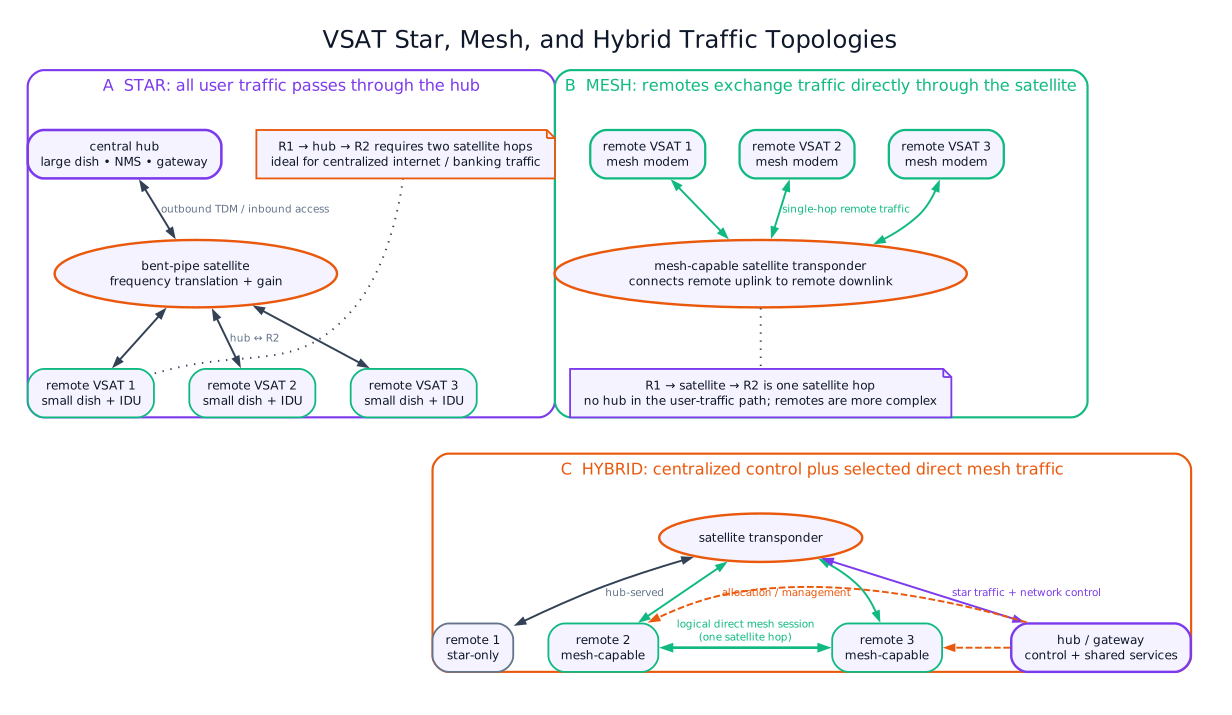
VSAT Network Topologies
| Topology | Description | Use |
|---|---|---|
| Star topology | Remote VSATs communicate through a central hub | Banking, corporate networks, internet access |
| Mesh topology | VSATs communicate directly through satellite | Voice networks, low-latency site-to-site links |
| Hybrid topology | Combination of star and mesh | Large enterprise networks |
VSAT Block Diagram
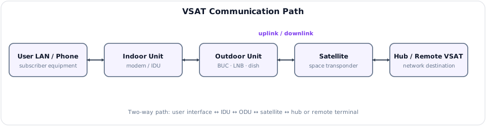
| Part | Function |
|---|---|
| IDU | Indoor unit; modem and user interface |
| ODU | Outdoor unit; dish, BUC, LNB, feed |
| BUC | Block upconverter; converts and amplifies uplink signal |
| LNB | Low-noise block downconverter; receives and downconverts downlink signal |
Applications
- Bank ATM and branch connectivity.
- Rural internet and telephony.
- Enterprise private networks.
- Disaster recovery communication.
- Remote education and telemedicine.
- Oil, gas, hydro, and remote project sites.
Advantages
- Rapid deployment in remote areas.
- Independent of terrestrial infrastructure.
- Wide coverage.
- Reliable backup link.
Limitations
- Propagation delay, especially through GEO satellite.
- Rain fade at Ku/Ka bands.
- Limited bandwidth compared with fiber.
- Requires clear line of sight to satellite.
9. Satellite Link Budget
Likely Exam Question (10 marks)
"What is satellite link budget? Explain EIRP, free-space path loss, G/T, and carrier-to-noise ratio."
Definition
A link budget is an accounting of all gains and losses from transmitter to receiver to determine received carrier power and communication quality.
Effective Isotropic Radiated Power
where:
- \(P_t\) = transmitter power
- \(G_t\) = transmit antenna gain
- \(L_t\) = transmitter feeder and pointing losses
Free-Space Path Loss
where:
- \(d_{km}\) = distance in km
- \(f_{MHz}\) = frequency in MHz
Received Carrier Power
where:
- \(G_r\) = receive antenna gain
- \(L_{other}\) = atmospheric, rain, polarization, pointing, and feeder losses
Carrier-to-Noise Density Ratio
The noise density is:
In dB form, Boltzmann's constant is:
Carrier-to-noise density ratio:
Carrier-to-Noise Ratio
For receiver bandwidth \(B\):
where \(B\) is in Hz.
Energy per Bit to Noise Density Ratio
For bit rate \(R_b\):
where \(R_b\) is in bit/s.
Common Link Losses
| Loss | Cause |
|---|---|
| Free-space loss | Spreading over long distance |
| Atmospheric absorption | Oxygen and water vapor absorption |
| Rain attenuation | Rain scattering/absorption, severe at Ku/Ka bands |
| Polarization loss | Mismatch between transmit and receive polarization |
| Pointing loss | Antenna not pointed exactly at satellite |
| Feeder loss | Waveguide/cable loss between equipment and antenna |
| Implementation loss | Modem and hardware imperfections |
10. Signal-to-Noise Ratio in Satellite Links
Likely Exam Question (5 marks)
"Define SNR and explain its importance in satellite communication."
Definition
Signal-to-noise ratio (SNR) is the ratio of received signal power to noise power.
In dB:
Noise power:
In dB:
where:
- \(k\) = Boltzmann's constant
- \(T\) = system noise temperature in K
- \(B\) = bandwidth in Hz
Importance
- Determines link quality.
- Affects bit error rate.
- Determines modulation and coding choice.
- Sets minimum antenna size and transmitter power.
- Helps decide link margin under rain fading.
11. Multiple Access in Satellite Systems
Likely Exam Question (5 marks)
"Write short notes on FDMA, TDMA, and CDMA in satellite communication."
| Technique | Principle | Feature |
|---|---|---|
| FDMA | Each earth station uses a different frequency band | Simple but less flexible |
| TDMA | Earth stations transmit in assigned time slots | Efficient for digital traffic |
| CDMA | Stations use different spreading codes | Resistant to interference, flexible access |
| DAMA | Demand Assigned Multiple Access | Channels assigned only when needed |
DAMA
Demand Assigned Multiple Access assigns satellite capacity dynamically based on traffic demand.
It is useful in VSAT and rural telephony networks where users do not transmit continuously.
12. Propagation Effects
Likely Exam Question (5 marks)
"Explain rain fade and Faraday rotation in satellite communication."
| Effect | Description | Important At |
|---|---|---|
| Rain attenuation | Signal absorption/scattering by rain | Ku, Ka, higher bands |
| Atmospheric absorption | Loss due to oxygen and water vapor | Microwave/mmWave |
| Scintillation | Rapid signal fluctuation due to atmosphere/ionosphere | Low elevation angles |
| Faraday rotation | Polarization rotation by ionosphere | Lower frequencies |
| Doppler shift | Frequency shift due to relative motion | LEO/MEO systems |
| Sun outage | Solar noise aligns with satellite direction | GEO links near equinox |
Rain Fade Mitigation
- Increase link margin.
- Use uplink power control.
- Use larger antenna.
- Use lower frequency band where possible.
- Use adaptive coding and modulation.
Model Answer — Satellite Communication, Kepler's Laws, and Atmospheric Loss [2+3+5=10, NTC 2079]
Exam-ready answer
(a) Satellite communication [2 marks]
Satellite communication uses an artificial earth satellite as a microwave relay between distant earth stations. The transmitting earth station sends an uplink; the satellite transponder receives, filters, amplifies and frequency-converts it; and the receiving station obtains the retransmitted downlink.
(b) Kepler's laws of orbital motion [3 marks]
- Law of orbits: a satellite follows an elliptical orbit with the earth at one focus.
- Law of areas: the earth-satellite radius vector sweeps equal areas in equal times; therefore the satellite moves faster near perigee and slower near apogee.
- Law of periods: the square of orbital period is proportional to the cube of semi-major axis:
where \(T\) is orbital period, \(a\) is semi-major axis, and \(\mu=GM_E\) is earth's gravitational parameter.
(c) Most important atmospheric loss above 10 GHz [5 marks]
For an ordinary rainy earth-space path above about 10 GHz, rain attenuation is usually the most important variable atmospheric impairment. Raindrops absorb part of the wave energy and scatter part away from the receiving antenna. Because drop dimensions become significant relative to wavelength, attenuation generally rises with frequency, rain rate, effective rain-path length and polarization mismatch.
The specific attenuation is commonly represented by
where \(R\) is rain rate and \(k,\alpha\) depend on frequency and polarization. Rain fade reduces received \(C/N\), increases BER and may cause outage, particularly in Ku- and Ka-band links.
Mitigation methods are:
- adequate fade margin;
- uplink power control;
- adaptive coding and modulation;
- site diversity or a lower-frequency fallback; and
- greater receive antenna gain where practical.
Qualification: oxygen and water-vapour absorption must also be included in a link budget and become especially important near resonance bands such as about 22 GHz and 60 GHz. Thus rain is the expected dominant weather-dependent loss, not an exceptionless statement for every frequency and climate.
Practice target: 16–18 minutes; divide answer space approximately in the ratio 2:3:5.
Model Answer — Satellite-Orbit Classification and LEO–MEO–GEO Comparison [10 marks]
Exam-ready answer
A satellite orbit is its gravitational free-fall path around earth. Altitude and orbital shape set period, velocity, footprint, propagation delay, free-space loss and ground-terminal tracking. By altitude/geometry, communication orbits are low earth orbit (LEO), medium earth orbit (MEO), geostationary earth orbit (GEO) and highly elliptical orbit (HEO).
| Property | LEO | MEO | GEO |
|---|---|---|---|
| Typical altitude | About \(500\)–\(2000\,\text{km}\) | About \(2000\)–\(20000\,\text{km}\) for common navigation systems | \(35786\,\text{km}\) above equator |
| Period/apparent motion | About 90–120 min; rapid sky motion | Several hours; moving | One sidereal day; stationary to ground observer |
| One-satellite footprint | Small, moving | Medium | Very large, nearly one-third of earth excluding high polar regions |
| Delay and path loss | Lowest | Moderate | Highest |
| Constellation/tracking | Many satellites, frequent handover and tracking | Moderate number, tracking | About three give near-global nonpolar coverage; fixed dish possible |
| Main use | Broadband constellations, mobile service, imaging | GPS/GNSS and other navigation | DTH TV, FSS, trunking and VSAT |
HEO has low perigee and high apogee. A satellite dwells near apogee, so inclined HEO constellations can serve high latitudes that GEO covers poorly, at the cost of changing range, Doppler and tracking.
Kepler's laws govern every class: an orbit is an ellipse with earth at one focus, equal areas are swept in equal times, and
where \(T\) is in s, semi-major axis \(a\) in m and earth parameter \(\mu\approx3.986\times10^{14}\,\text{m}^3/\text{s}^2\).
A satellite is geostationary only if its orbit is circular, in the equatorial plane, prograde (same direction as earth rotation), and has \(T=86164\,\text{s}\), one sidereal day. Hence
For an overhead relay, minimum ground-to-ground one-way propagation time is roughly \(2h/c\): about \(6.7\,\text{ms}\) through a \(1000\,\text{km}\) LEO versus \(239\,\text{ms}\) through GEO, before routing/processing and with real slant paths often longer. Free-space loss also grows as \(20\log_{10}d\). Thus LEO gives low latency and small terminals but demands a large managed constellation, Doppler tracking and inter-satellite/user handovers. GEO gives fixed pointing and continuous broad coverage but high delay/loss, poor polar elevation, expensive launch/station keeping and strong Ku/Ka rain-fade exposure. MEO is a compromise, especially for navigation.
Practice target: 18 minutes; draw both orbit figures, derive GEO radius from the sidereal period and reproduce the six-row comparison.
Model Answer — GEO Uplink and Downlink Design Factors [5 marks, NTC 2081]
Exam-ready answer
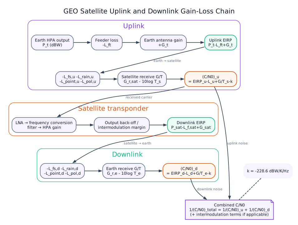
A GEO link has two physical sections: earth-station modem/upconverter/HPA/dish → uplink → satellite receive antenna, LNA, filter/frequency converter and HPA → downlink → receiving dish/LNA/downconverter/modem. Each section must deliver the required carrier-to-noise density ratio with fade and implementation margin.
The main design factors are:
- transmitter power, feeder loss and antenna gain, combined as \(EIRP=P_t+G_t-L_t\) in dBW;
- slant range and frequency, giving \(L_{fs}=32.44+20\log_{10}d_{km}+20\log_{10}f_{MHz}\) dB;
- atmospheric gas, cloud and especially rain attenuation above about \(10\,\text{GHz}\), plus polarization and pointing losses;
- receive antenna gain and system noise temperature, summarized by \(G/T\) in dB/K;
- allocated bandwidth, modulation/FEC, bit rate and required \(E_b/N_0\) or BER;
- satellite transponder bandwidth, gain, EIRP, intermodulation and input/output back-off; and
- availability target, interference coordination, hardware loss, aging and link margin.
For either section,
then \(C/N=C/N_0-10\log_{10}B\) for receiver bandwidth \(B\) in Hz. At a representative \(38000\,\text{km}\) slant range, FSPL is about \(207.0\,\text{dB}\) at \(14\,\text{GHz}\) and \(205.6\,\text{dB}\) at \(12\,\text{GHz}\), before atmospheric loss.
Many systems place the higher frequency on the uplink because a ground station can use a larger dish and HPA to overcome the extra loss, while the power-limited satellite uses the lower-loss downlink; frequency separation also permits simultaneous relay. This is a common allocation practice, not a universal physical law. Ku/Ka designs need rain statistics, fade margin, uplink power control or adaptive coding, while C-band is less rain-sensitive but uses larger antennas. The final design must satisfy both uplink and downlink availability without saturating the transponder.
Practice target: 9 minutes; draw the two-section chain, write EIRP and C/N0 equations and state at least six design factors including qualified rain loss.
Model Answer — Satellite Stabilization, Tracking and Earth Stations [10 marks]
Exam-ready answer
Stabilization maintains spacecraft attitude so communication antennas point toward the footprint and solar arrays/sensors retain their required orientation. Station keeping is different: it corrects orbital longitude, inclination and eccentricity against earth oblateness, lunar/solar gravity and solar-radiation pressure. Tracking estimates satellite direction and drives a ground antenna, while an earth station originates/terminates traffic and controls the RF link.
Spin stabilization rotates the spacecraft body, using angular momentum for passive attitude stiffness; a bearing-driven despun platform keeps the communications antenna earth-pointing. It is mechanically simple but constrains payload/large-array arrangement. Three-axis stabilization uses sun/earth/star sensors and gyros, an attitude controller, and reaction wheels for roll, pitch and yaw. Thrusters provide acquisition and unload wheel momentum. It gives accurate flexible pointing but needs more sensors, actuators and control logic. North-south and east-west thruster burns keep a GEO satellite inside its assigned orbital box; propellant commonly limits service life.
Ground tracking may be program track from predicted ephemeris, manual/step track from measured beacon level, or closed-loop automatic/monopulse tracking from angular error. The servo converts beacon error into azimuth and elevation motor commands and uses shaft encoders for feedback. A fixed GEO terminal needs little continuous motion after alignment, but narrow-beam large dishes still need correction; LEO/MEO stations must follow rapidly changing azimuth/elevation and compensate Doppler.
The earth-station transmit chain is user data/codec → FEC and modulator at IF → upconverter → high-power amplifier (TWTA/SSPA) → feeder/duplexer → parabolic dish. The satellite transponder receives, filters, amplifies and frequency-translates it. The receive chain is dish/feed → low-noise amplifier or LNB placed near the feed → downconverter/IF filtering → demodulator, FEC decoder and user output. Frequency/time references, power supply, redundancy, alarms and monitor/control support both chains; a VSAT packages these functions into an indoor modem and small outdoor BUC/LNB/dish.
Dish gain and receiver figure of merit are
For \(D=3\,\text{m}\), \(f=12\,\text{GHz}\) so \(\lambda=0.025\,\text{m}\), and \(\eta=0.6\), \(G\approx8.53\times10^4=49.3\,\text{dBi}\). If system noise temperature is \(150\,\text{K}\), \(G/T\approx49.3-21.8=27.5\,\text{dB/K}\). Increasing diameter raises gain but narrows beamwidth, making pointing error more critical; placing the LNA before lossy cable protects low noise temperature.
These systems support broadcast, gateway, telemetry/control, remote enterprise and disaster links. Limitations are GEO delay, rain/gaseous loss, blockage, HPA nonlinearity, expensive precision antennas and failure from poor tracking or exhausted station-keeping fuel. Stable spacecraft attitude, accurate ground pointing and a high-EIRP/high-G/T earth station must therefore be designed as one link.
Practice target: 18–20 minutes; divide time among stabilization/station keeping, tracking loop and complete earth-station chains, then finish with the gain and G/T calculation.
13. Solved Examples
Example 1 - GEO Propagation Delay
Q. Approximate one-way propagation delay for a GEO satellite link, taking satellite altitude as \(35786\,\text{km}\) and using vertical path approximation.
Solution:
Actual slant path delay is often about \(120\) to \(140\,\text{ms}\) one way, and a double-hop or round-trip path is much larger.
Example 2 - Free-Space Path Loss
Q. Find free-space path loss for a satellite downlink at \(4\,\text{GHz}\) and slant range \(40000\,\text{km}\).
Solution:
Example 3 - EIRP
Q. A transmitter power is \(20\,\text{W}\), antenna gain is \(40\,\text{dBi}\), and feeder loss is \(2\,\text{dB}\). Find EIRP in dBW.
Solution:
Example 4 - Noise Power
Q. Receiver system temperature is \(500\,\text{K}\) and bandwidth is \(1\,\text{MHz}\). Find noise power in dBW.
Solution:
14. Quick Revision Table
| Topic | Key Point |
|---|---|
| Uplink | Earth to satellite |
| Downlink | Satellite to earth |
| Transponder | Receives, amplifies, frequency-converts, retransmits |
| GEO altitude | About \(35786\,\text{km}\) |
| GEO period | One sidereal day |
| Kepler's third law | \(T^2 = 4\pi^2a^3/\mu\) |
| C-band | Around 6/4 GHz uplink/downlink |
| Ku-band | Around 14/11-12 GHz |
| Ka-band | Around 30/20 GHz |
| EIRP | \(P_t + G_t - L_t\) in dB units |
| Free-space loss | \(32.44 + 20\log d_{km} + 20\log f_{MHz}\) |
| G/T | Receive antenna gain to system noise temperature ratio |
| C/N0 | Link quality per Hz, in dBHz |
| VSAT | Very Small Aperture Terminal |
Key Exam Points — Satellite Communication
- Satellite communication uses uplink, transponder, and downlink paths.
- GEO satellites appear stationary but have high delay and path loss.
- LEO satellites have low delay but need constellations and handovers.
- Kepler's third law relates orbital period and orbital radius.
- Link budget includes EIRP, path loss, receive gain, G/T, noise, and margins.
- VSAT is widely used for remote connectivity, banking, backup links, and rural communication.